


finding_nimo
MyBoerse.bz Pro Member
Killetsoft TRANSDAT Professional v24.00 Multilingual
Killetsoft TRANSDAT Professional v24.00 Multilingual | 5 MB | Language: Multilanguage
TRANSDATpro - Geodetic Coordinate Transformations and Datum Shifts worldwide with high accuracy. TRANSDATpro performs Coordinate Transformations fast and with high accuracy. The coordinate conversion software supports worldwide thousands of Coordinate Systems, geodetic Reference Systems and Datum Shifts, user-defined systems, 2D/3D transformations, INSPIRE, NTv2, HARN, EPSG, GPS, continental drift and more.
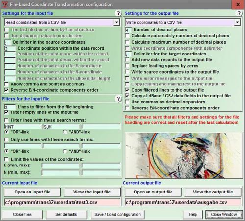
The geographic calculator reads and writes the file systems Text, CSV, SDF, dBase, Arc-Shape, Arc-Generate, KML, GPX and others. Furthermore: Outdoor GPS reception, mapping in Google Earth, Google Maps and OpenStreetMap, Meridian Convergence and Extra Parameter, Polygonal scopes in NTv2 files, multilingual user interface. Besides the usual Geographic Information Systems (GIS), there is a wide variety of geodetic applications and data collections that are used for the acquisition, processing and presentation of spatial data. The thereby used spatial data are available in many different coordinate systems and reference systems. Here the program TRANSDATpro is needed to transform the spatial data of different data sources and data structures from one coordinate reference system (CRS) to another. TRANSDATpro has been developed on the basis of the Geodetic Development Kit GeoDLL, which allows to embed geodetic calculations in own computer programs.
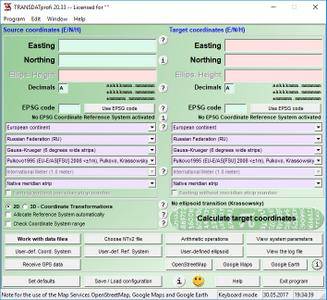
TRANSDATpro is a professional computer program for Geodetic Coordinate Transformations between national and country-specific Coordinate and Reference Systems with high precision and good performance:.
The current and historical Systems of all countries of Europe
The European ETRS89 systems forced by INSPIRE
The US and Canadian NAD, NTv2, HARN and SPCS Coordinate Reference Systems
The Coordinate Reference Systems of most countries of all continents
The Coordinate Reference Systems of Germany, Austria and Switzerland incl. NTv2
The Geographic coordinates in different notations and Cartesian coordinates
Worldwide NTv2 gridfile supported Coordinate Transformations
Worldwide used numeric and alphanumeric Coordinate Systems
Most of EPSG supported Coordinate Reference Systems
ITRS annual realizations or WGS84 epochs for GPS measurements
WGS84 Coordinate Transformations in consideration of the continental drift
User defined Coordinate Systems, Reference Systems and earth ellipsoids
Meridian Convergence, Origin Center Meridian, Geographical Point Coordinates
Using the example of Germany, the there available Coordinate Reference System are broken down in more groups:
The Coordinate Reference Systems of the old and new German Federal States
The German 'Lagestatus' Coordinate Reference Systems
The high-precision Reference Systems of the German Federal States incl NTv2
The 40 Soldner Coordinate Systems of the Prussian Land Registers
You find a complete list of the supported Coordinate and Reference Systems on our internet site and after downloading (see above) the free test version as part of the documentation.
TRANSDATpro supports all by the INSPIRE directive prescribed ETRS89 conversions with NTv2 grid data, e,g. Gauss-Kruger / DHDN to UTM / ETRS89 with BeTA2007. The NTv2 standard with national gridfiles is worldwide full supported. The use of EPSG codes for the Coordinate Reference Systems is possible. Apart from the given worldwide and state-specific systems, your own personal Coordinate Systems and geodetic Reference Systems can be defined with Helmert (Bursa / Wolf, ISO19111) or Molodensky Parameters. Calculations can be performed with coordinates entered directly, loaded from files in various formats (Text, CSV, SDF, dBase, KML, GPX, ArcShape and ArcGenerate), or passed via batch processing. Arc-Shapefiles can be viewed with the program-internal Shape Viewer. A programmable GPS interface makes it possible to read coordinates into a notebook computer from a low-cost GPS antenna.
The program has a user-selectable multi language interface and comes with extensive online help. The program can be run on most common networks and it is possible to use Terminal Services on WINDOWS Servers. In case of a network installation the clients are installed automatically by the program.
What's new:
Homepage:
Größe: 5 MB
Sprache: Multilingual-Deutsch
Format: .rar / .exe
Plattform: Windows (32 Bit 64 Bit)
HOSTER:
K2s.cc (Keep2Share)
Rapidgator.net
Nitroflare.com
Uploadgig.com
DOWNLOAD