• Regeln für den Software-Bereich:


    Allgemeines:

    - In erster Linie sind unsere Boardregeln zu beachten, zu finden HIER.
    - Software zur Audiobearbeitung sollte ausschließlich im Unterforum "Audio" eingestellt werden.
    - Für Cracks, Keygens oder sonstige Freischaltungssoftware gibt es das Unterforum "Freischaltung".
    - Portable Software bitte im entsprechenden Unterforum "Portable Software" eintragen.
    - Diskussionen zur Installation und anderen Problemen mit der Software, bitte im enstprechenden Unterforum "Talk" führen.
    - Bei Unklarheiten und Fragen zu den Regeln bitte die Moderatoren kontaktieren.


    Angebot erstellen

    - Die Struktur des Threadtitels muss wie folgt umgesetzt werden: Herstellername - Softwarename - Versionsnummer
    - Unnötige Zusätze im Threadtitel wie "HOT", "NEW" oder Punkte zwischen den Wörtern sind nicht erlaubt.
    - Achtet darauf immer nur die Hauptversion und deren Updates in einem Thread zusammenfassen, konkretes Beispiel: SoftwareXY v3.12 gehört in den selben Thread mit SoftwareXY v3.13; SoftwareXY v.4.1 gehört in einen neuen eigenen Thread. Ausgenommen hiervon sind Sammelthreads und Dauerangebote.
    - Bei nicht bekannten Herstellern oder Angebote einer privaten Software, ist die Programmbezeichnung + Versionsnummer ausreichend.
    - Besondere Beachtung gilt für den ersten Beitrag eines Angebots. Dort muss eine kurze Beschreibung der Software in deutscher Sprache angegeben werden. Für offizielle Releases ist es Pflicht die NFO im Beitrag einzustellen(Spoiler, siehe nächster Punkt).
    - Weitere Informationen wie NFOs oder Changelogs, versteckt ihr bitte in einem Spoiler.


    Software Suche

    - Für Suchanfragen haben wir das Unterforum "Suche" erstellt.
    - Auch hier sollte vorher die Suchfunktion benutzt werden, um Doppelthreads vorzubeugen. Sollte es bereits eine Suchanfrage geben, könnt ihr den Thread gerne mit einem "Danke" pushen.


    Trojaner- und Virusalarm

    - Falls Euer Virenscanner bei einem Angebot Alarm schlägt, solltet ihr zunächst Ruhe bewahren. Viele Virenscanner erkennen Cracks/Keygens oft fälschlicherweise als Bedrohung.
    - Prüft die verdächtige Datei zuerst mit http://virustotal.com , sollte es sich hierbei wirklich um eine Bedrohung handeln, meldet den Beitrag und/oder wendet euch mit dem Bericht von VirusTotal.com an einen Moderator.


    Unerwünschte Angebote

    - Keylogger, Spionagetools, alles rund ums Thema Hacking/Cracking ist nicht erwünscht.
  • Bitte registriere dich zunächst um Beiträge zu verfassen und externe Links aufzurufen.


OkMap v13

mikemike

MyBoerse.bz Pro Member

OkMap 13.1.0 Multilingual

001ab374_mediummszm8.jpeg


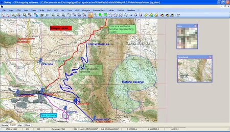
OkMap is an interactive software which allows you to work on your computer screen with digital maps that you have either bought or scanned. OkMap can also import vectorial data from the most common formats and DEM data relevant to height informations.

Through these maps, you can organize your paths by creating waypoints, routes and tracks on your computer monitor, and upload this data to your GPS. To make it easier, OkMap provides you also with autorouting and geocoding functions.

Data collected by your GPS can be downloaded on your computer, stored and displayed on the maps. They can also be used to create different types of statistics.

By connecting a GPS to your laptop, you can plot your position on maps in real-time. If you are connected to the network you can constantly send your position to a remote computer, or receive the position of your companions on your computer and display the related tracks on maps in real time.

OkMap can also interface Google Maps and Google Earth. With Google Maps you can get portions of maps immediately available in OkMap. With Google Earth you can view your paths and your maps also in 3D.

OkMap include a feature to generate automatically compatible "Garmin Custom Maps" (kmz format). This feature includes map tiling from and to different image file formats (including ECW map format). It’s possible select KML extensions 2.2 (if GPS supports them), the JPEG quality, the image resizing, the KML transparency, the draw order, and so on. You can also select the tiles to generate in output. This feature support "not north oriented" maps also.

OS: Windows
Lang: Multilingual
Size: 40,08 MB
Format: .exe
Hoster: Uploaded
PW: boerse


Directload
 

OkMap 13.1.1 Multilingual


001ab374_mediummszm8.jpeg


OkMap is an interactive software which allows you to work on your computer screen with digital maps that you have either bought or scanned. OkMap can also import vectorial data from the most common formats and DEM data relevant to height informations.

Through these maps, you can organize your paths by creating waypoints, routes and tracks on your computer monitor, and upload this data to your GPS. To make it easier, OkMap provides you also with autorouting and geocoding functions.

Data collected by your GPS can be downloaded on your computer, stored and displayed on the maps. They can also be used to create different types of statistics.

By connecting a GPS to your laptop, you can plot your position on maps in real-time. If you are connected to the network you can constantly send your position to a remote computer, or receive the position of your companions on your computer and display the related tracks on maps in real time.

OkMap can also interface Google Maps and Google Earth. With Google Maps you can get portions of maps immediately available in OkMap. With Google Earth you can view your paths and your maps also in 3D.

OkMap include a feature to generate automatically compatible "Garmin Custom Maps" (kmz format). This feature includes map tiling from and to different image file formats (including ECW map format). It’s possible select KML extensions 2.2 (if GPS supports them), the JPEG quality, the image resizing, the KML transparency, the draw order, and so on. You can also select the tiles to generate in output. This feature support "not north oriented" maps also.

OS: Windows
Lang: Multilingual
Size: 40,08 MB
Format: .exe
Hoster: Uploaded
PW: boerse


Directload
 

OkMap 13.2.0 Multilingual


001ab374_mediummszm8.jpeg


OkMap is an interactive software which allows you to work on your computer screen with digital maps that you have either bought or scanned. OkMap can also import vectorial data from the most common formats and DEM data relevant to height informations.

Through these maps, you can organize your paths by creating waypoints, routes and tracks on your computer monitor, and upload this data to your GPS. To make it easier, OkMap provides you also with autorouting and geocoding functions.

Data collected by your GPS can be downloaded on your computer, stored and displayed on the maps. They can also be used to create different types of statistics.

By connecting a GPS to your laptop, you can plot your position on maps in real-time. If you are connected to the network you can constantly send your position to a remote computer, or receive the position of your companions on your computer and display the related tracks on maps in real time.

OkMap can also interface Google Maps and Google Earth. With Google Maps you can get portions of maps immediately available in OkMap. With Google Earth you can view your paths and your maps also in 3D.

OkMap include a feature to generate automatically compatible "Garmin Custom Maps" (kmz format). This feature includes map tiling from and to different image file formats (including ECW map format). It’s possible select KML extensions 2.2 (if GPS supports them), the JPEG quality, the image resizing, the KML transparency, the draw order, and so on. You can also select the tiles to generate in output. This feature support "not north oriented" maps also.

OS: Windows
Lang: Multilingual
Size: 58,61 MB
Format: .exe
Hoster: Uploaded
PW: boerse


Directload
 

OkMap 13.4.1 Multilingual


001ab374_mediummszm8.jpeg


OkMap is an interactive software which allows you to work on your computer screen with digital maps that you have either bought or scanned. OkMap can also import vectorial data from the most common formats and DEM data relevant to height informations.

Through these maps, you can organize your paths by creating waypoints, routes and tracks on your computer monitor, and upload this data to your GPS. To make it easier, OkMap provides you also with autorouting and geocoding functions.

Data collected by your GPS can be downloaded on your computer, stored and displayed on the maps. They can also be used to create different types of statistics.

By connecting a GPS to your laptop, you can plot your position on maps in real-time. If you are connected to the network you can constantly send your position to a remote computer, or receive the position of your companions on your computer and display the related tracks on maps in real time.

OkMap can also interface Google Maps and Google Earth. With Google Maps you can get portions of maps immediately available in OkMap. With Google Earth you can view your paths and your maps also in 3D.

OkMap include a feature to generate automatically compatible "Garmin Custom Maps" (kmz format). This feature includes map tiling from and to different image file formats (including ECW map format). It’s possible select KML extensions 2.2 (if GPS supports them), the JPEG quality, the image resizing, the KML transparency, the draw order, and so on. You can also select the tiles to generate in output. This feature support "not north oriented" maps also.

OS: Windows
Lang: Multilingual
Size: 58,69 MB
Format: .exe
Hoster: Uploaded
PW: boerse


Directload
 
Zurück
Oben Unten